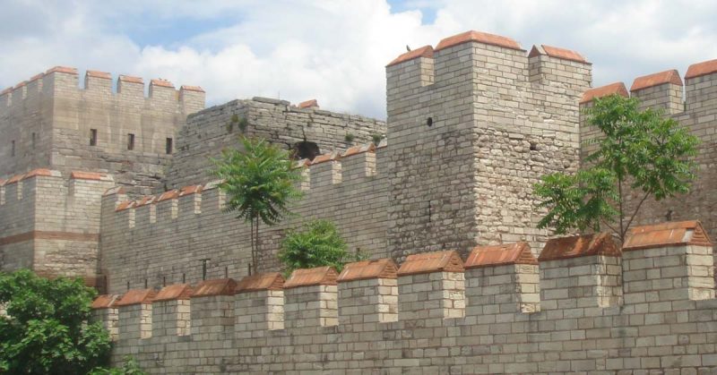
The great city of Constantinople was one of the most impressive and impregnable cities in the world for over 1,000 years. It retained the glory of the former capital of Rome while implementing new wonders. The city’s location, both on a continental scale and on a smaller topographical scale, had a profound impact on the city’s history and is still influential to the modern city. The city under the Byzantines enjoyed long periods of safety and prosperity and often had a population near or exceeding half a million residents.
Though the city prospered, the Empire often did not and this occasionally brought the city under direct threat of attack. From the very beginning of its establishment as a Roman capital, the city was threatened from the barbarian hordes of the west along with the ancient enemy of Persia to the East. Emperors understood that the capital must be heavily defended and the defense of the city was a high priority.
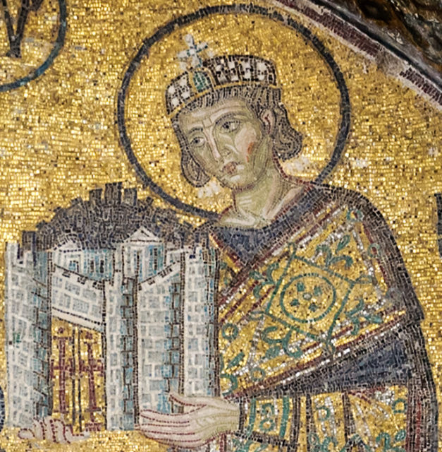
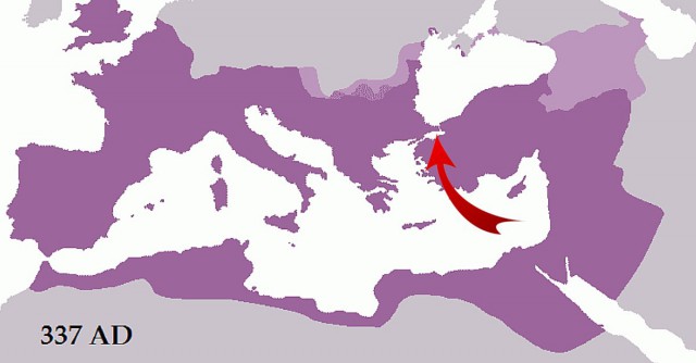
As the Roman Empire fell into various stages of chaos and civil wars, eventually a powerful leader emerged to quell rebellions and unify the empire again. This was Constantine I, who was able to become sole emperor by 324 after defeating his rivals in the East. Constantine understood that the core wealth of the Empire lay in the Eastern provinces while Rome remained poor and vulnerable to threats. He deliberated on several Eastern relocations of a new capital. He had ideas for the coastal city of Thessalonica as well as the fortified inland city of Serdica (modern Sofia). He eventually settled on Byzantium based on its location.
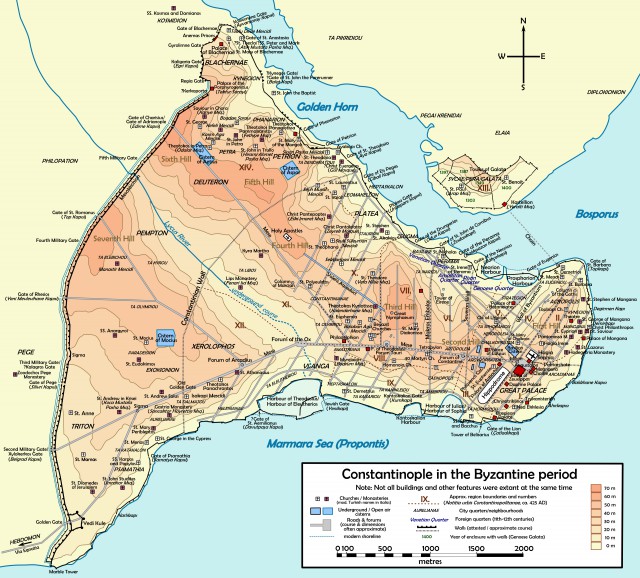
The city as the capital was in a prime geographical location for the Empire as it allowed the Romans to efficiently monitor and confront threats by the barbarians and the Persians. Previously, wars with the Persians required substantial travel and news and orders from Rome took far too long. The city was situated on a blunt peninsula which had the bay known as the Golden Horn to its north leading northward to the straights of the Bosporus and the Black Sea.
On the Eastern and Southern coasts laid the Marmara Sea which would lead south and join with the Aegean and Mediterranean Sea. The sea-lanes were vital to the city’s economy and provided lucrative trade opportunities. The only outlet that the thousands of miles of coast along the Black Sea had was through the new capital. The Black Sea offered a diverse range of trade as it bordered Europe on the West, modern Russia and the Crimean Peninsula to the North and Anatolia and Armenia to the East. Almost all land trade between Europe and Asia crossed directly through Constantinople and the growth of the city only encouraged more trade.
Though the geographical location was important for trade, it was also vital for the defense of the city. Being surrounded on three sides by water, the only land defenses needed was a wall on the western end of the city. Waterway connecting the Sea of Marmara and the Bosporus had strong currents which made sustained blockades difficult and the calm waters of the Golden Horn were easily accessible to the city and could be easily defended by a chain stretched across the entrance. Not only were the seven hills of Constantinople symbolically representative of the Seven Hills of Rome, they also improved the natural defenses of the city.
When Constantine took control of the city the population had grown past the walls built by the Byzantines and the walls built during the city’s Romanization. Constantine attempted to anticipate the future expansion of the city and started Construction on what would be known as the Constantinian walls. The walls were constructed two miles to the west of the previous fortifications where the peninsula began to widen from one to two miles across. The new walls gave the city over two square miles of room to grow and extended from coast to coast. Little is known about the size of the walls and though it is thought that Constantine also oversaw construction of the sea walls, there is little concrete evidence. The wall was supported by regular intervals of towers and was built as a continuous curtain wall. It was known to have remained for much of the early and middle Byzantine period despite being replaced. It gradually fell into disrepair over the later centuries though the relative layout of the city remained corralled by the wall for centuries. The wall was completed during the reign of Constantius II 337-361.
Constantinople suffered no direct attacks while under the protection of the Constantine walls. The population steadily grew and eventually expanded past the wall along both coastlines. The city was thriving and was beginning to become known as a major city rivaling Rome by the later 4th century. Then a horrible defeat at the battle of Adrianople left Constantinople without an emperor or sizeable army. The emperors of Constantinople made peace with the Goths and within thirty years work began on the most famous walls of Constantinople, the Theodosian Walls.
Construction on the Theodosian Walls was actually thought to have been started while their namesake, Theodosius II, was still an infant. The work started at the beginning of the 5th century amidst great fears of barbarian invasions. The wall was initially planned as a single curtain wall starting a little over a mile west of the Constantinian walls. The wall was twelve meters tall with crenellated battlements and was five to six meters thick. The interior of the wall was filled with crushed limestone and brick and the wall was faced with cut limestone and several horizontal layers of brick which helped to anchor sections of the wall and improve absorption of missiles and earthquakes along with being quite decorative. Ninety-six towers strengthened the walls and were 15-20 meters tall and 10 meters wide jutting outward from the main wall. The towers provided flanking fire to any attacker trying to scale the walls and their great height allowed for a greater range for defenders.
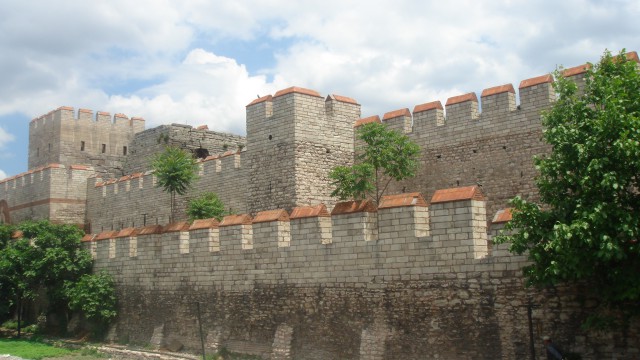
In front of the main curtain walls was another wall. This outer wall was two meters thick and nine meters tall and was fortified with several towers often located between the larger towers of the inner wall reaching as high as fourteen meters and being four meters thick, relatively small when compared to the main towers. This outer wall was easily accessible by small postern gates within the main towers and a space of land fifteen to twenty meters wide separated the inner and outer walls, allowing an optimal distance from which the inner wall could support the outer one. In addition to the two walls, a twenty meter wide moat was also located in front of the outer wall. This moat was unique in that it was twenty meters in front of the outer wall and had a series of battlements on ground level which allowed defenders to assemble in front of the actual walls and lay down suppressive fire on any attackers attempting to cross the moat. It was quite possible that these battlements allowed defenders to safely deploy hand-pumped Greek fire which would burn fiercely on top of the water filled moat. This triple line of defense was a masterpiece of early medieval fortifications.
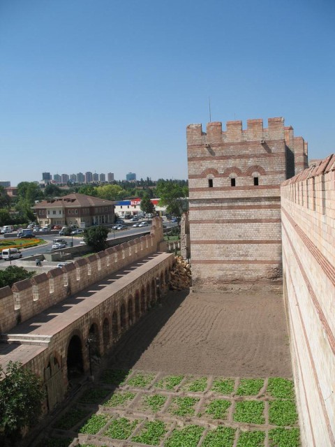
Not only were these walls three separate formidable obstacles, they also complimented each other perfectly. The wide moat would stall any initial attack and leave besiegers vulnerable to missile attacks from the battlements of the moat, the outer wall and the inner wall simultaneously. Any besieger hoping to scale the walls had to first cross the moat, but they also had to have two heights of scaling ladders. If over the first wall, attackers found themselves severely exposed to attack from the inner walls. Even the chance of success after scaling the inner wall was limited due to the thickness of the wall which enabled rapid deployment of troops to any hotspot along the wall. The spacing between the walls allowed defenders to form a bottleneck defense in the event of a wall collapsing. Mining under walls in order to collapse them was a common tactic of the day and in the event of a breach, the spacing forced attackers to risk being flanked if the defenders could position themselves on either side of the breach. Several gates lined the walls but they were so heavily guarded with robust towers that attackers often ignored them.
The complete walls stretched 3 ½ miles from the southern coast to the growing neighborhood of Blachernae on the northwest coast of the city. They were continued by the walls of Blachernae which were built and rebuilt several times and linked the land walls to the sea walls. The walls of Blachernae often appeared to be a weak point in the defense as they were mostly single-walled and jutted out from the Theodosian walls however they proved to be impermeable despite being targeted many times. The single walls of the neighborhood are difficult to accurately describe as they were altered several times however they were thicker than the Theodosian walls and had larger and closer towers. The walls were supported throughout the city’s history by several fortified palace complexes which often incorporated parts of the wall into their construction.
Though the empire and Constantinople did have their share of misfortune: Adrianople, The Nika riots, the wayward Fourth Crusade and the Plague, the Walls of the city and its stout defense were a huge source of pride as these people, who proudly considered themselves true Romans, held out far longer than they should have, being surrounded by so many hostile states.
By William McLaughlin for War History Online
